Sunday, August 30, 2009

Forest Carnage

You've seen many of the great scenic places I have been in my life. However, I have also seen a lot of "environmental ugliness" in my career. I'm currently on a mission to convince people that "letting nature take its course" is definitely NOT the thing to do, in this day and age. Posting pictures here means they will be available to me to post in eco-forums. A picture is worth a thousand words and, since I was once a "Freddie", my words are automatically tainted. Soooo, I think that posting pictures of the mess our forests are in will go a long way towards convincing people that our forests DO need human intervention and that they are NOT "doing just fine for the last 10,000 years without humans".
.
Here is a picture of the Lake Tahoe area behind Kings Beach, during the early 90's drought and bark beetle emergency. Environmentalists and misguided people stopped much of the salvage efforts and most of the dead trees you see in this picture have fallen over and lie in wait for the next inevitable lightning fire. In this dry summer environment, wood simply doesn't decay into soil. It BURNS!


Eco's always try to say that wildfires are "beneficial" and "low-intensity". This shot of Oregon's Biscuit Fire shows, without a doubt, that fires indeed cause forest destruction and very longterm damage. Even with a minimum of ground cover, due to rocky terrain, the fire burned with such intensity that it killed almost every single tree.
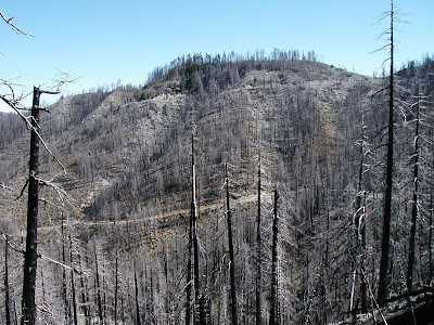


Here is another picture in the same area of the Biscuit Fire. For as far as you can see in the distance, the fire killed trees and burned up spotted owl nesting sites, and habitat. The areas that weren't salvaged, due to them being within Spotted Owl "circles", are now doomed to burn again, causing hellish fire intensities near the ground and sterilizing soils for decades into the future. They will no longer be able to support the large trees that were once there.
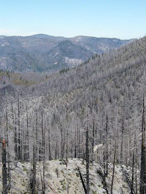


Here is a dramatic picture of a burn area in the Bitterroot National Forest, where mortality looks to be about 90%. The wood became unusable due to litigation against the Forest Service and now, this area is also doomed to burn again, at high intensity. The original fire is clearly NOT "beneficial", and the land will suffer for decades.


Here is an example of a "biological wildfire", where bark beetles have overwhelmed every single pine in the area of Camp Seeley, near Crestline, in the San Bernardino National Forest. A lack of scientific forest management allowed this forest to become overstocked with trees, causing it to be ultra-sensitive to even minimal drought. As the drought worsened, the entire forest became completely stressed and the bark beetles "bloomed" into an unstoppable force and the forests had no defense against them.

Labels: , , , , , ,

Sunday, August 23, 2009

Sentinel Rock and Glacier Point

I took yet another trip to smoky Yosemite and my destination was Sentinel Rock. I have been atop Sentinel Dome twice in the past so, I just walked on by it on my way to the edge of Yosemite Valley. I had a vague idea that Sentinel Rock wasn't very easy to get to but, I wanted to check out that rugged part of the Park for myself. When I wandered off the trail, I found that there was a 15 foot wall blocking my access and there was no way to safely drop off. I looked and looked and there was a potential way of getting there but that would involve a similarly dangerous "long way around".
So, I cut my losses and snapped off as many pics as i wanted and planned my Plan B. Right here is a picture of the farthest I could get, standing on a cliff, looking towards the massive El Capitan.


I spied this snag growing on the edge of the rugged cliff of Sentinel Rock so, I took out my telephoto lens and zoomed into the snag with El Capitan as a background.


I was hoping that Yosemite Falls would still have a pretty good flow, with Sentinal Rock being just right across the valley. The early snowmelt has drained the watershed of fresh springwater and it now is a scant trickle, as you can see. This is a quite different view of the famous Upper Falls and part of the very interesting inner gorge.


Here is a distant view of North Dome and Basket Dome, pulled in with my telephoto lens. Years ago, I took a hike and visited the top of both of them. Very few people go there, with the 10 mile roundtrip from the Tioga Pass Road.


Walking back via the trail, I had this nice view of Half Dome. Zooming into this shot, using Photoshop, I could see individual people on top of this Yosemite icon. Clouds Rest looms behind Half Dome and the peak has, arguably, the best view in all of Yosemite. I was once there and took pictures but, the roll of film somehow disappeared. Maybe I'll make it back up there, one day.


Labels: , , , ,

Tuesday, August 04, 2009

Tioga Pass

I was itching to go to Yosemite and had intended to have an adventure on the edge of Yosemite Valley but, smoke from a local wildfire was too thick for good photography. Instead, I decided to go up the Tioga Pass Road (Highway 120) and see if the smoke was dissipating at the higher elevations. Even Tuolumne Meadows had some smoke so I went even higher.

Here is the view from the parking lot at Tioga Pass, almost 10,000 feet above sea level.


My destination was one of the Gaylor Lakes, mostly above timberline. I didn't use the polarizer on this shot, to see the differences. I do like how the reflection on the lake is enhanced when the polarizer isn't used.


I wandered out this and found some great spots, including this view of Mammoth Peak and the Kuna Crest. Even though these peaks are above 12,000 feet, they are not taller than Mount Dana and the Sierra Crest.


Also on that ridge, you can see the Cathedral Range, looking to the west. Named by John Muir, the Cathedral Range is an impressive polished granitic monument. Many Yosemite visitors never see the higher elevations of Yosemite.


On the way back down, I stopped off at Tenaya Lake to snap off some pics at this magical place. The lake was busy with picnickers, climbers, boaters and even swimmers in the cool water.


Labels: , , ,